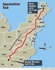
First, let me say Thank You to everyone. Your support, interest, kind words, and gift packages have made this entire journey much much easier. This was definitely a once in a lifetime journey. Amazing, amazing, amazing. Above is a picture of me at the top of Katahdin with the official sign, which was actually only a day or two old. It replaced one that was so worn it could barely be read or seen from a distance greater than 1 ft. Nice timing.
After an interesting and fun time in Bangor, Portland, and Boston I am back home in NYC. YEA!!!
From what I’ve heard and read, 2009 was one of the wettest years on record for northbound thru-hikers. As I go back through my journal entries I think it rained or snowed almost 70% of my hike. A journey of this distance and type will obviously take its toll on any gear, but the amount of moisture my gear encountered was much greater than expected. Regardless, I believe for any piece of gear to make it through the types of torture encountered on a five month Appalachian Trail thru hike is absolutely incredible and a testament to its quality.
Some of my original gear was switched out within the first week of starting my journey, and some of my gear successfully made it through the whole trip. Below is a list of items that made it to the end. I’m including items that I kept with me the entire trip and those I sent home when the weather changed and then had sent back to me when I got further north. Basically, this is anything that didn’t break, fall apart, disintegrate, blow off my head or body on top of a mountain, succumb to the rain, ignite and burn up, or prove to be worthless and not needed.
EMS Velocity 35 sleeping bag
Campmor 20 sleeping bag
THERM-A-REST ProLite 3 short sleeping pad (never even had a leak)
Six Moon Designs Lunar Solo tarp tent (this is a beast)
Leatherman Micra multi-tool
Apple iPhone 3G
Trangia alcohol stove and wind screen
EMS Thunderhead rain jacket
EMS Techwick balaclava
EMS Ascent down sweater
EMS Techwick ¾ zip micro fleece
EMS Techwick midweight pants (long underwear)
Shure noise canceling headphones with mic for phone calls
Georgio Armani eye glasses from LensCrafters
Icebreaker wicking underwear (3 pairs for the entire trip) WOW.
There are several items that belong on an honorable mention list with more detail. Here they are with explanations.
ULA Conduit backpack. This is a great frameless, barebones pack. I went through two of these before giving up on it at Port Clinton, PA. Brian at ULA was amazing and the pack was great, but the stitching couldn’t handle all of the rain, snow, freezing and thawing that I had to deal with during the first half of the hike. Brian replaced my first pack at Atkins, VA when the stitching on both shoulder straps and the hip belt gave out. The same thing happened with the second pack, and by the time I reached Port Clinton I had restitched the straps several times. I will take part of the blame because I probably over packed it early in the hike.
Osprey Exos 46 (2009 model). I purchased this pack at the outfitter in Port Clinton, and it survived the remainder of the hike – through rain, rain, rain, snow, hail, wind, and even some very nice weather. It rides better than any other pack I’ve ever strapped onto my back, and it has the right mix of compression straps, pockets, and lash points. I love this pack.
MSR titanium pot/kettle. Before I began the hike I decided this pot was too expensive and not worth the weight savings. I quickly changed my mind once I was on the trail, and I bought one at the outfitter at Neels Gap, within one week of starting. I kept it the rest of the journey, using it as a pot and as a cup. This is one of those pieces of gear that I don’t think I’ll ever hike or camp without. It is simply amazing.
GSI Compact Scraper. I saw people using these all along the trail in Georgia, North Carolina, and Tennessee and thought it was a stupid piece of gear, but I kept my eye on them to see how and why they thought it was needed. Well, the reasons to have this are many. I caved in and bought one at the outfitter in Waynesboro, VA. I used it everyday for the rest of my hike, and I love it. It can be used as an eating utensil (used it when my spork broke and then again when I lost my next spork), as a pot cleaner, as a knife to cut food, as a tool to clean other gear, even as a zipper pull, and for other purposes.
Keen Voyageur hiking shoes. I went through 5 pairs of shoes on this hike; several were complete duds but these were absolutely amazing. Not the lightest weight pair you can buy, but they are comfortable and indestructible. The soles are solid and flex just enough for AT hiking, and they also drain water really well which is another plus for AT hiking. At least that is my experience.
EMS midweight hiking socks. I started with three pairs and switched out all of them at the halfway point. Six pairs of socks for five months is not too bad considering all the moisture and cold weather they endured.
Until later,
I'm already finding the move back to normal life a bit more of a struggle than I thought it would be. Life as I have known it for the last 5 months is now completely gone. Well, not completely gone...my knees, hips, and feet still hurt and I'm still very hungry all the time.
Between thinking about and looking for employment I will be working on developing (electronically) my photos and posting them somewhere for all to view. I'll add a link on this site to their final resting place as soon as they are up. I will also send an email to anyone who is interested.
As I sit here typing and watching Kandra's six fish (Dave, Dave, Dave, Dave, Dave, and Dave) I'm reminded of the one very big thing I learned from the trail = Balance is good. Therefore, the next "J.O.B." will need to complement the other pieces of my life better than the last one did...and the other pieces will need to be and stay in place. :)
The sun is shining here in NYC this morning and they are predicting it to be Hot and Muggy (90+ F) today. I can't help but be thankful that I never had to hike in temps that high, but at the same time I have the urge to strap something to my back and go walking.
From what I’ve heard and read, 2009 was one of the wettest years on record for northbound thru-hikers. As I go back through my journal entries I think it rained or snowed almost 70% of my hike. A journey of this distance and type will obviously take its toll on any gear, but the amount of moisture my gear encountered was much greater than expected. Regardless, I believe for any piece of gear to make it through the types of torture encountered on a five month Appalachian Trail thru hike is absolutely incredible and a testament to its quality.
Some of my original gear was switched out within the first week of starting my journey, and some of my gear successfully made it through the whole trip. Below is a list of items that made it to the end. I’m including items that I kept with me the entire trip and those I sent home when the weather changed and then had sent back to me when I got further north. Basically, this is anything that didn’t break, fall apart, disintegrate, blow off my head or body on top of a mountain, succumb to the rain, ignite and burn up, or prove to be worthless and not needed.
EMS Velocity 35 sleeping bag
Campmor 20 sleeping bag
THERM-A-REST ProLite 3 short sleeping pad (never even had a leak)
Six Moon Designs Lunar Solo tarp tent (this is a beast)
Leatherman Micra multi-tool
Apple iPhone 3G
Trangia alcohol stove and wind screen
EMS Thunderhead rain jacket
EMS Techwick balaclava
EMS Ascent down sweater
EMS Techwick ¾ zip micro fleece
EMS Techwick midweight pants (long underwear)
Shure noise canceling headphones with mic for phone calls
Georgio Armani eye glasses from LensCrafters
Icebreaker wicking underwear (3 pairs for the entire trip) WOW.
There are several items that belong on an honorable mention list with more detail. Here they are with explanations.
ULA Conduit backpack. This is a great frameless, barebones pack. I went through two of these before giving up on it at Port Clinton, PA. Brian at ULA was amazing and the pack was great, but the stitching couldn’t handle all of the rain, snow, freezing and thawing that I had to deal with during the first half of the hike. Brian replaced my first pack at Atkins, VA when the stitching on both shoulder straps and the hip belt gave out. The same thing happened with the second pack, and by the time I reached Port Clinton I had restitched the straps several times. I will take part of the blame because I probably over packed it early in the hike.
Osprey Exos 46 (2009 model). I purchased this pack at the outfitter in Port Clinton, and it survived the remainder of the hike – through rain, rain, rain, snow, hail, wind, and even some very nice weather. It rides better than any other pack I’ve ever strapped onto my back, and it has the right mix of compression straps, pockets, and lash points. I love this pack.
MSR titanium pot/kettle. Before I began the hike I decided this pot was too expensive and not worth the weight savings. I quickly changed my mind once I was on the trail, and I bought one at the outfitter at Neels Gap, within one week of starting. I kept it the rest of the journey, using it as a pot and as a cup. This is one of those pieces of gear that I don’t think I’ll ever hike or camp without. It is simply amazing.
GSI Compact Scraper. I saw people using these all along the trail in Georgia, North Carolina, and Tennessee and thought it was a stupid piece of gear, but I kept my eye on them to see how and why they thought it was needed. Well, the reasons to have this are many. I caved in and bought one at the outfitter in Waynesboro, VA. I used it everyday for the rest of my hike, and I love it. It can be used as an eating utensil (used it when my spork broke and then again when I lost my next spork), as a pot cleaner, as a knife to cut food, as a tool to clean other gear, even as a zipper pull, and for other purposes.
Keen Voyageur hiking shoes. I went through 5 pairs of shoes on this hike; several were complete duds but these were absolutely amazing. Not the lightest weight pair you can buy, but they are comfortable and indestructible. The soles are solid and flex just enough for AT hiking, and they also drain water really well which is another plus for AT hiking. At least that is my experience.
EMS midweight hiking socks. I started with three pairs and switched out all of them at the halfway point. Six pairs of socks for five months is not too bad considering all the moisture and cold weather they endured.
Until later,
L
Posted from my Macbook while sitting in a comfy chair in my living room.